On this page (6 sections)
The shape of the airport
JFK covers 4,930 acres on Jamaica Bay in southeastern Queens, threaded by more than 30 miles of internal roadway, and the core passengers spend their time in is the Central Terminal Area, 880 acres where six terminal buildings stand around a road loop. The terminals are numbered 1, 4, 5, 6, 7, and 8, and the gaps are real: Terminal 3 was demolished in 2013, Terminal 2 in 2023. The terminal guide covers which airlines use each.
Reading the map clockwise from the water: Terminal 4 anchors the south of the loop, Terminal 1 the west, Terminal 8 the northwest corner, Terminal 7 the north, and Terminal 5 the east, with the new Terminal 6 rising between Terminals 5 and 7 on the north side. Its first gates are due to open during 2026, it is built to integrate with Terminal 5, and no airline checks in there yet. The whole airport is inside a $19 billion rebuild, so treat any map of it as a snapshot.
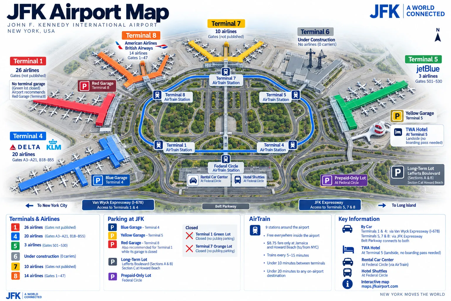
Two AirTrain lines leave the property toward the city. Much of what else is on the map, parking areas, rental cars, hotel shuttles, the Lefferts Boulevard wait lot, hangs off the train that connects them, which is why the next section is the closest thing JFK has to a subway map of itself.
The AirTrain, station by station
The AirTrain is the map's spine: nine stations, free everywhere inside the airport, with the $8.75 fare charged only on entry or exit at the two city gateways. Trains run every 5 to 15 minutes, terminal to terminal takes under 10 minutes, and the airport puts any on-airport destination at under 20. Three services cover the system: one out to Jamaica, one out to Howard Beach, and a shuttle that just circles the terminals. The two outbound lines part ways at Federal Circle. The AirTrain guide owns fares and payment; here is what sits at each stop, as the airport's own route map lists it.
- Jamaica: the Long Island Rail Road, three of the four connecting subway lines (the E, J, and Z), and local buses.
- Howard Beach: the A train's gateway, the one-seat ride toward lower Manhattan and much of Brooklyn, plus long-term parking section C.
- Lefferts Boulevard: long-term parking sections A and B, the free wait lot for pickups and drop-offs, and the B15, Q10, and Q3 city buses.
- Federal Circle: the rental car center, the hotel shuttle area, cargo shuttles, and the prepaid-only parking lot. The junction where the Jamaica and Howard Beach lines meet the terminal loop.
- Terminal 1: first stop on the loop from Federal Circle.
- Terminal 4: with the Blue parking garage.
- Terminal 5: with the Yellow garage and the TWA Hotel.
- Terminal 7: serving the north side while Terminal 6 fills in beside it.
- Terminal 8: with the Red garage and the Q3 bus, last stop before the loop hands back to Federal Circle.
The order matters when you are tired and counting stops: from Federal Circle the train reaches Terminal 1 first and Terminal 8 last. On board, the rules are short: no eating, drinking, or smoking, and bicycles are welcome at four per car, though bikes are not permitted on the Central Terminal Area roadways at any time.
Terminal by terminal around the loop
Each terminal is its own building with its own security, so the JFK terminal map question is really six smaller maps. Three of the six have full map guides: the Terminal 4 map (36 gates, two concourses, the longest published walk at 10 to 14 minutes), the Terminal 5 map (gates 501 to 530), and the Terminal 8 map (gates 1 to 47 in four blocks). The rest, spatially, in one line each:
- Terminal 1: west side of the loop, long-haul international, every gate 1 to 5 minutes from security. It closes into the New Terminal One when that opens; no date is settled.
- Terminal 6: north side, between Terminals 5 and 7, first five gates due in 2026 with the rest to come. No airline checks in there, and its developer describes it as built to integrate with Terminal 5.
- Terminal 7: north side, every gate 1 to 5 minutes from security, operating until the second phase of Terminal 6 construction begins, per its own operator.
The moving pieces are the reason a dated map beats a pretty one. Terminal 7 is emptying into Terminal 6 ahead of demolition, Terminal 1's replacement is under construction on the old Terminal 2 site, and airlines move between buildings on short notice. Check the terminal overview for who flies where before you trust any drawing, including the airport's own.
Roads, entrances, and the lots
By road, the map splits by terminal. The airport's guidance as of September 2026: the Van Wyck Expressway (I-678) gives direct access to Terminals 1 and 4, and the JFK Expressway gives direct access to Terminals 5, 7, and 8, with the Belt Parkway feeding both. Construction re-cuts the approaches, so at the final split the posted sign outranks the GPS. The address and directions guide carries the GPS entries, the curb rules, and the two free wait lots: the Cell Phone Lot near the JFK Expressway for Terminals 5, 7, and 8, and the Lefferts Boulevard wait lot for Terminals 1 and 4.
Parking follows the same color logic as the stations: Blue garage at Terminal 4, Yellow at Terminal 5, Red at Terminal 8, the long-term lot at Lefferts Boulevard, and the prepaid-only lot at Federal Circle. Terminals 1 and 7 have no open garage of their own under the rebuild; the airport recommends the Red garage for Terminal 1's drivers, and it is the cheapest of the three at the gate. Rates and the prebook discount live on the parking pages.
Finding specific things
Here are the spots people actually hunt for, gathered in one place. The rental car center and the hotel shuttle area are both at Federal Circle Station, one free AirTrain ride from any terminal. The TWA Flight Center, the landmark 1962 terminal now operating as the TWA Hotel, sits at Terminal 5. The free wait lots for drivers are at Lefferts Boulevard and near the JFK Expressway, covered above.
Moving between terminals means the AirTrain and a fresh security screening at the far end, and there is no walking route between the buildings, so allow 20 minutes for the train alone plus the line when you get there. Smoking has its own small geography at JFK and the smoking areas guide covers it; the one rule this page can state is the AirTrain's own, which is no smoking on board.
When you need the live map
For a specific gate, counter, restaurant, or door, use the airport's own interactive map at maps.jfkairport.com. It carries terminal layouts, walking routes and times, gate locations, AirTrain stations, parking, dining, and the ride app pickup zones. It is also the place to see what is open today, which no static page can show.
That is the honest division of labor. Gate assignments, outlet openings, and pickup zones change daily and belong to the live tool. The shape of the airport, the loop order, the station list, and which garage is where are the durable part, and they are what this page holds.